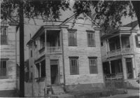
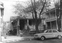
House on site affected by the construction of the Crosstown. Address: 114 Sheppard Street. Surveyor notations on back of photo: "Dkt.: 10.524. Property owner: Lillian M. Anderson, Est. Tract: 145. Station: 19+20 Rt. S.B. lane. Date: Dec. 2, 1964. In R/W - Bought." [See collection description for explanation of surveyor notations.]
House on site affected by the construction of the Crosstown. Address: 114 Sheppard Street. Surveyor notations on back of photo: "Dkt.: 10.524. Property owner: Lillian M. Anderson, Est. Tract: 145. Station: 19+20 Rt. S.B. lane. Date: Dec. 2, 1964. In R/W - Bought." [See collection description for explanation of surveyor notations.]
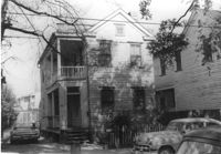
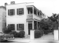
House on site affected by the construction of the Crosstown. Address: 124 Sheppard Street. Surveyor notations on back of photo: "Dkt.: 10.524. Property owner: Reynard P. Hill, Esq. Tract: 135. Station: 17+05 Lt. S.B. lane. Date: Dec. 2, 1964. In R/W - Bought." [See collection description for explanation of surveyor notations.]
House on site affected by the construction of the Crosstown. Address: 124 Sheppard Street. Surveyor notations on back of photo: "Dkt.: 10.524. Property owner: Reynard P. Hill, Esq. Tract: 135. Station: 17+05 Lt. S.B. lane. Date: Dec. 2, 1964. In R/W - Bought." [See collection description for explanation of surveyor notations.]
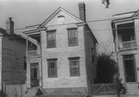
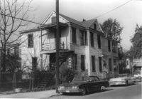
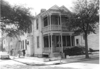
House on site affected by the construction of the Crosstown. Address: 126 Sheppard Street. Surveyor notations on back of photo: "Dkt.: 10.524. Property owner: Nathaniel M. Johnson. Tract: 134. Station: 16+70 Lt. S.B. lane. Date: Dec. 2, 1964. In R/W - Bought." [See collection description for explanation of surveyor notations.]
House on site affected by the construction of the Crosstown. Address: 122 Sheppard Street. Surveyor notations on back of photo: "Dkt.: 10.524. Property owner: Archie B. Hollins. Tract: 136. Station: 17+40 Lt. S.B. lane. Date: Dec. 2, 1964. In R/W - Bought." [See collection description for explanation of surveyor notations.]
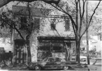
House on site affected by the construction of the Crosstown. Address: 117 Bogard Street. Surveyor notations on back of photo: "Dkt.: 10.524. Property owner: Paul Mack. Tract: 56. Station: 74+25 Rt. Date: Oct. 14, 1964." [See collection description for explanation of surveyor notations.]
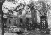
House on corner of Sheppard and Ashe Streets (rear and side views), on site affected by the construction of the Crosstown. Address: 125 Sheppard Street. Surveyor notations on back of photo: "Dkt.: 10.524. Property owner: Joseph A. Moore, et al. Tract: 130. Station: 91+90 Rt. Date: Dec. 2, 1964. In R/W - Bought." [See collection description for explanation of surveyor notations.]
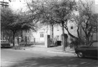
House on corner of Sheppard and Ashe Streets, on site affected by the construction of the Crosstown. Address: 125 Sheppard Street. View of street corner. Surveyor notations on back of photo: "Dkt.: 10.524. Property owner: Joseph A. Moore, et al. Tract: 130. Station: 91+90 Rt. Date: Dec. 2, 1964. In R/W - Bought." [See collection description for explanation of surveyor notations.]
Mitchell Elementary School, on site affected by the construction of the Crosstown. Address: 132 Sheppard Street. Surveyor notations on back of photo: "Dkt.: 10.524. Property owner: Charleston County School Dist. #20. Tract: 131. Station: 91+45 Lt. Date: Dec. 2, 1964. Moving item." [See collection description for explanation of surveyor notations.]