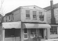
Side view of corner grocery store on site affected by the construction of the Crosstown. Address: 121 America Street. Surveyor notations on back of photo: "Dkt.: 10.518. Property owner: Vallie Talbert. Tract: 58. Station: 49+50 Lt. N.B. lane Route 17. Date: Mar. 7, 1963." [See collection description for explanation of surveyor notations.]
M&F Food Store on site affected by the construction of Interstate 26 (I-26). Address: 14 D Street. Surveyor notations on back of photo: "Dkt.: 10.517. Property owner: Frank Lea. Tract: 13. Station: 5944+55 Rt. - Line 6. Date: February 21, 1963. In R/W - Bought." [See collection description for explanation of surveyor notations.]
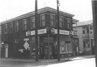
Push Grocery located at the southwest corner of Fishburne and St. Philip Streets, on site affected by the construction of Interstate 26 (I-26). Address: 77 Fishburne Street. Surveyor notations on back of photo: "Dkt.: 10.517. Property owner: Margaret J. Finn. Tract: 110. Station: 24+50 Lt. Southbound Lane Route 17. Date: March 5, 1963. In R/W - Bought." [See collection description for explanation of surveyor notations.]
Push Grocery at the southwest corner of Fishburne and St. Philip Streets (rear corner/southeast elevation), on site affected by the construction of Interstate 26 (I-26). Address: 77 Fishburne Street. View of street corner. Willie's Grill, across the street, in background. Surveyor notations on back of photo: "Dkt.: 10.517. Property owner: Margaret J. Finn. Tract: 110. Station: 24+50 Lt. Southbound Lane Route 17. Date: March 5, 1963. In R/W - Bought." [See collection description for explanation of surveyor notations.]
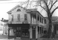
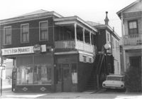
Pye's Fish Market, on site affected by the construction of the Crosstown. Address: 71 Lee Street. View of street corner. Same building as previous two photographs. `Surveyor notations on back of photo: "Dkt.: 10.518. Property owner: Virginia E.R. Ehlers. Tract: 28. Station: 41+15 CL S.B. lane Route 17. Date: Mar. 6, 1963. In R/W - Bought. [See collection description for explanation of surveyor notations.]
Pye's Fish Market, on site affected by the construction of the Crosstown. Address: 71 Lee Street. Same building as previous three photographs. `Surveyor notations on back of photo: "Dkt.: 10.518. Property owner: Virginia E.R. Ehlers. Tract: 28. Station: 41+15 CL S.B. lane Route 17. Date: Mar. 6, 1963. In R/W - Bought. [See collection description for explanation of surveyor notations.]
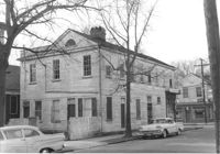
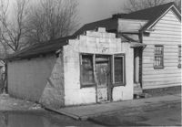
Building, possibly a store previously, on site affected by the construction of Interstate 26 (I-26). Address: 26A Addison Street [26 Addison Street]. Front facade has stepped parapet. Surveyor notations on back of photo: "Dkt.: 10.503. Property owner: Alice Campbell Johnson. Tract: 96. Station: 5919+10 Rt. Date: Feb. 20, 1963. In R/W - Bought." [See collection description for explanation of surveyor notations.]
Right of way--South Carolina--Charleston County, Highway planning--South Carolina--Charleston County, Commercial buildings--South Carolina--Charleston County, Vernacular architecture--South Carolina--Charleston County, Lost architecture--South Carolina--Charleston County, Grocery stores--South Carolina--Charleston County✖[remove]7