Search
« Previous |
1,051 - 1,100 of 1,145
|
Next »
Search Results
Description:
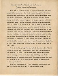
Summary of an interview done with Mrs. Kinloch and Mr. Grice regarding parking and traffic conditions between 1939 and 1943.
Description:
List of city owned property in congested traffic areas compiled by the committee on "Inventory of City Owned Property in Congested Areas."
Description:
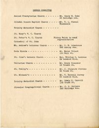
List of members of the Civic Services Committee Church Committee.
Description:
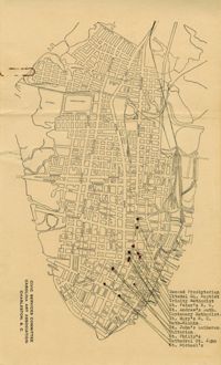
Map of the Charleston peninsula showing churches in congested areas.
Description:
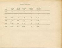
Table depicting the traffic violations from the year 1937-1942. The violations are broken down by race and gender.
Description:
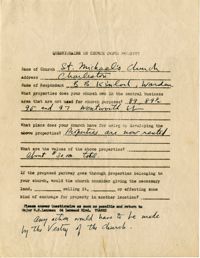
Church owned property questionnaire filled out for St. Michael's Church.
Description:
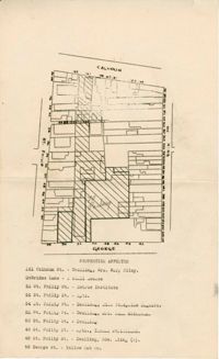
Map of area bounded by Calhoun Street, King Street, George Street, and St. Philip Street.
Date:
1944-10-17
Description:
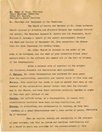
Resolutions made by the Board of Vestry and Wardens of St. John's Lutheran Church (Oct. 17, 1944).
Date:
1944-08-01
Description:
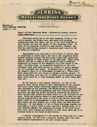
Report of C. Bissell Jenkins on fire insurance rates affected by present interior block conditions (August 1, 1944).
Description:
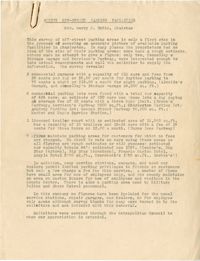
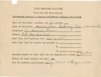
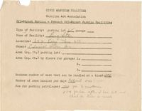
Results of the off-street parking facilities survey in Mrs. Harry M. Rubin's report.
Description:
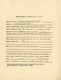
Church owned property questionnaire filled out for Circular Congregation Church on 138-150 Meeting Street.
Description:
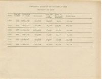
Table of Comparative Statement of Property at Risk Insurance and Loss for the years 1900, 1910, 1920, 1930, 1940, and 1942.
Description:
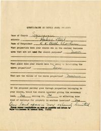
Church owned property questionnaire filled out for Synagogue on Hasell Street.
Description:
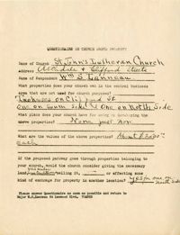
Church owned property questionnaire filled out for St. John's Lutheran Church.
Description:
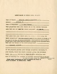
Church owned property questionnaire filled out for Unitarian Church of Charleston, SC.
Description:
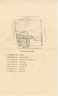
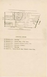
Map of area bounded by Wentworth Street, St. Philip Street, Beaufain Street, and King Street.
Description:
Blank off-street parking form for present off-street parking facilities attached to area list (List of areas 1-13).
Description:
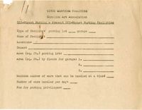
Off-street parking facilities survey filled out for Marion Square (County Center).
Description:
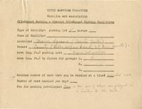
Off-street parking facilities survey filled out for Joe Rutledge at 192 St. Philip Street.
Description:
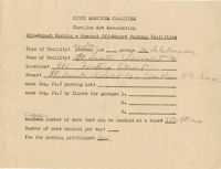
Off-street parking facilities survey filled out for Fort Sumter Chevrolet Co.
Date:
1944-10-24
Description:
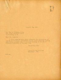
Letter to W. S. Lanneau from Robert N.S. Whitelaw regarding the resolutions of the Board of Vestry and Wardens of St. Johns Lutheran Church (Oct. 24, 1944).
Description:
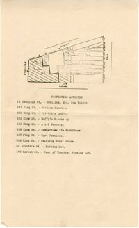
Map of area bounded by Wentworth Street, Meeting Street, Hasell Street, and King Street.
Description:
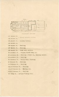
Map of area bounded by Archdale Street, Beaufain Street, King Street, and Market Street.
Description:
Map of area bounded by Market Street, King Street, Princess Street, and Archdale Street.
Description:
Off-street parking facilities survey filled out for Burn's Lane Parkway.
Description:
Off-street parking facilities survey filled out for Big Star.
Date:
1944-12-09
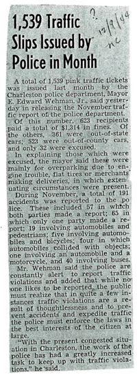
Description:
News and Courier article (Dec. 9, 1944), "1,539 Traffic Slips Issued by Police in Month."
Date:
1944-10-01
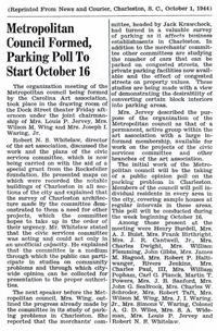
Description:
News and Courier article (Oct. 1, 1944), "Metropolitan Council Formed, Parking Poll to Start Oct. 16."
Date:
1945-11-05
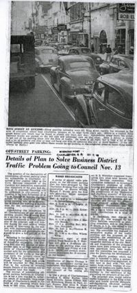
Description:
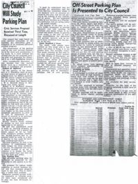
Charleston Evening Post article (Nov. 5, 1945), "Off-Street Parking: Details of Plan to Solve Business District Traffic Problem Going to Council Nov. 13."
Date:
1945-11-08
Description:
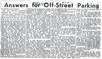
News and Courier article (Nov. 8, 1945), "Answers for Off-Street Parking."
Date:
1945-11-14
Description:
News and Courier article (Nov. 14,1945), "City Council will Study Parking Plan."
Description:
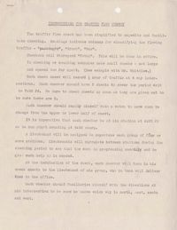
A document entitled "Instructions for Traffic Flow Survey." This document gives instruction on how to complete a traffic survey, and the intersections where the Charleston Boy Scouts needed to be.
Description:
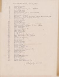
Document with the boy scout traffic count (June 1, 1944).
Date:
1944-11-27
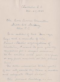
Description:
Letter to the Civic Services Committee from Mrs. John G. Seabrook regarding a war memorial suggestion (Nov. 27, 1944).
Date:
1945-07
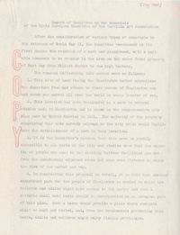
Description:
Report entitled "Report of Committee on War Memorials" (July, 1945), sent to Mayor Wehman.
Date:
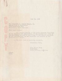
1945-07-19
Description:
Letter to Mayor E. Edward Wehman from Mrs. Wilson Wing enclosing a report on war memorials (July 19, 1945).
Date:
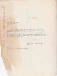
1945-03-17
Description:
Letter to Mrs. Wilson Wing from Robert N.S. Whitelaw informing her about the subcommittee to study war memorials (March 17, 1945).
Description:
Statement regarding the Civic Services Committee's efforts regarding war memorials in Charleston.
Date:
1945-01-08
Description:
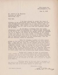
Letter to Robert N.S. Whitelaw from Loutrel W. Briggs, accepting his being elected to the Charleston Civic Services Committee (Jan. 8, 1945).
Date:
1945-07-21
Description:
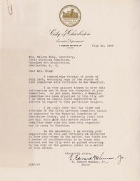
Letter to Mrs. Wilson Wing from Mayor E. Edward Wehman regarding the "Report of Committee on War Memorials" (July 21, 1945).
Date:
1943-12
Description:
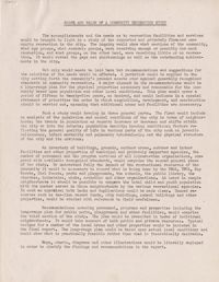
Report entitled "Scope and Value of a Community Recreation Study" by the National Recreation Association (Dec., 1943).
Date:
1941-03
Description:
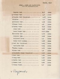
List and corresponding data on the parks and playgrounds of Charleston with the acreage (March, 1941).
Description:
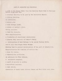
List of suggested war memorials for Charleston.
Date:
1945-01-25
Description:
Letter to Robert N.S. Whitelaw from Susan P. Frost in response to his reply to her, regarding her concern about parks being segregated (Jan. 25, 1945).
Description:
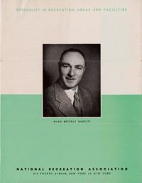
Brochure describing Alan Beverly Burritt (Specialist in Recreation Areas, Facilities, and Related Structures) and his services.
Date:
1944-12-05, 1944-12-12
Description:
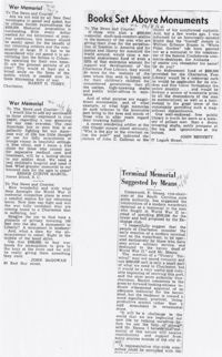
Three articles regarding war memorials in Charleston, SC including a letter to the editor from Ferdinanda L. Waring (Dec. 5 and 12, 1944).
Date:
1944-12-05, 1944-12-06
Description:
Three articles regarding war memorials in Charleston, SC (Dec. 5-6, 1944).
Date:
1944-12-07, 1944-12-08
Description:
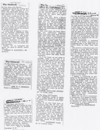
Four articles regarding war memorials in Charleston, SC (Dec. 7-8, 1944).
Date:
1944-12
Description:
Five articles regarding war memorials in Charleston, SC (Dec. 9-18, 1944).